
Category:Georgia State Route 3
 | number: | (three) |
|---|---|---|
| State highways in Georgia (U.S. state): | 1 · 2 · 3 · 4 · 5 · 6 · 7 · 8 · 9 · 10 · 11 · 12 · 13 · 14 · 15 · 16 · 17 · 18 · 19 · 20 · 21 · 22 · 23 |
State highway in western Georgia  | |||||
| Upload media | |||||
| Instance of | |||||
|---|---|---|---|---|---|
| Location | Georgia | ||||
| Transport network | |||||
| Owned by | |||||
| Maintained by | |||||
| Inception |
| ||||
| Length |
| ||||
| |||||
English: State Route 3 (SR 3) is a state highway that runs south-to-north through portions of Thomas, Mitchell, Dougherty, Lee, Sumter, Schley, Taylor, Upson, Pike, Spalding, Henry, Clayton, Fulton, Cobb, Bartow, Gordon, Whitfield, and Catoosa counties in western Georgia, bisecting the state and roughly paralleling I-75. The route runs from its southern terminus at US 19, SR 300, and FL 57 at the Florida state line, 12 miles south-southeast of Thomasville, to its northern terminus at US 41, US 76, and SR 8 at Tennessee state line near Chattanooga.
Subcategories
This category has the following 13 subcategories, out of 13 total.
S
T
Media in category "Georgia State Route 3"
The following 28 files are in this category, out of 28 total.
-
 Georgia 3 Connector.svg 600 × 600; 8 KB
-
 Advance Auto Parts, Tara Blvd, Clayton County.JPG 4,608 × 3,456; 4.92 MB
-
 Back the Blue, US19SB, Lee County.jpg 5,184 × 3,456; 6.6 MB
-
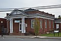
.JPG/120px-Baconton_Depot_(Southwest_corner).JPG) Baconton Depot (Southwest corner).JPG 5,152 × 3,864; 7.82 MB
Baconton Depot (Southwest corner).JPG 5,152 × 3,864; 7.82 MB
-
_viewed_from_Kennesaw_Mountain%2C_April_2017.jpg/120px-Cobb_Parkway_(US41)_viewed_from_Kennesaw_Mountain%2C_April_2017.jpg) Cobb Parkway (US41) viewed from Kennesaw Mountain, April 2017.jpg 3,127 × 2,169; 2.6 MB
Cobb Parkway (US41) viewed from Kennesaw Mountain, April 2017.jpg 3,127 × 2,169; 2.6 MB
-
.jpg/120px-Commercial_historic_district%2C_Ringgold_(Catoosa_County%2C_Georgia).jpg) Commercial historic district, Ringgold (Catoosa County, Georgia).jpg 1,024 × 768; 150 KB
Commercial historic district, Ringgold (Catoosa County, Georgia).jpg 1,024 × 768; 150 KB
-
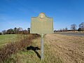
 Confederate Hospitals historical marker in Ringgold.jpg 6,016 × 4,000; 6.84 MB
-
 Family Dollar, Tara Blvd, Clayton County.JPG 4,608 × 3,456; 5.01 MB
-
 Flash Foods, 2336 Liberty Expressway, Dougherty County.JPG 4,608 × 3,456; 6.02 MB
-
 Georgia 3.svg 600 × 600; 4 KB
-
 Georgia State Route 3 Bypass SB end.jpg 5,184 × 3,456; 6.05 MB
-
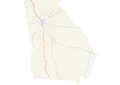 Georgia state route 3 map.png 2,900 × 2,058; 957 KB
-
 Kennesaw Mountain and Little Kennesaw Mountain.JPG 3,456 × 2,304; 3.33 MB
-
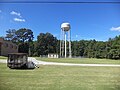 Lee County Water Tower.JPG 4,320 × 3,240; 4.56 MB
-
.JPG/120px-Leesburg_Depot_(South_corner).JPG) Leesburg Depot (South corner).JPG 4,320 × 3,240; 4.56 MB
Leesburg Depot (South corner).JPG 4,320 × 3,240; 4.56 MB
-
 Leesburg Shell Station.JPG 4,320 × 3,240; 4.58 MB
-
 Leesburg Tire.JPG 4,320 × 3,240; 4.57 MB
-
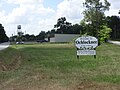 Ochlocknee welcome sign.JPG 4,608 × 3,456; 5.75 MB
-
.JPG/120px-Old_Stone_Church%2C_Ringgold_(Catoosa_County%2C_Georgia).JPG) Old Stone Church, Ringgold (Catoosa County, Georgia).JPG 1,024 × 768; 192 KB
Old Stone Church, Ringgold (Catoosa County, Georgia).JPG 1,024 × 768; 192 KB
-
 Papa John's, Tara Blvd, Clayton County.JPG 4,608 × 3,456; 5.42 MB
-
 Pizza Hut and China Kitchen, Clayton County.JPG 4,608 × 3,456; 4.08 MB
-
 Ranchero Mexican Restaurant, Clayton County.JPG 4,608 × 3,456; 4.73 MB
-
.JPG/120px-Ringgold_Depot%2C_Ringgold_(Catoosa_County%2C_Georgia).JPG) Ringgold Depot, Ringgold (Catoosa County, Georgia).JPG 1,024 × 768; 119 KB
Ringgold Depot, Ringgold (Catoosa County, Georgia).JPG 1,024 × 768; 119 KB
-
 Subway, Tara Blvd, Clayton County.JPG 4,608 × 3,456; 4.84 MB
-
 Tuscaloosa Formation historical marker, Taylor County.JPG 5,152 × 3,864; 7.9 MB
-
.jpg/120px-US280+US19+GA3+GA27+GA30+GA49TwoAssemblies-Americus_(22830101638).jpg) US280+US19+GA3+GA27+GA30+GA49TwoAssemblies-Americus (22830101638).jpg 2,400 × 1,600; 1.96 MB
US280+US19+GA3+GA27+GA30+GA49TwoAssemblies-Americus (22830101638).jpg 2,400 × 1,600; 1.96 MB
-
 Wedding chapel in Ringgold.jpg 6,016 × 4,000; 5.72 MB
-
 Wings Cafe, H&R Block, Tara Blvd, Clayton County.JPG 4,608 × 3,456; 4.48 MB


.JPG)
_viewed_from_Kennesaw_Mountain,_April_2017.jpg)
.jpg)


.JPG)


.JPG)


.JPG)


.jpg)


Categories:
- State highways in Georgia (U.S. state) by number
- Roads numbered 3
- Roads in Bartow County, Georgia
- Roads in Catoosa County, Georgia
- Roads in Clayton County, Georgia
- Roads in Cobb County, Georgia
- Roads in Fulton County, Georgia
- Roads in Gordon County, Georgia
- Roads in Lee County, Georgia
- Roads in Mitchell County, Georgia
- Roads in Schley County, Georgia
- Roads in Sumter County, Georgia
- Roads in Whitfield County, Georgia
- Roads in Worth County, Georgia